

|
|
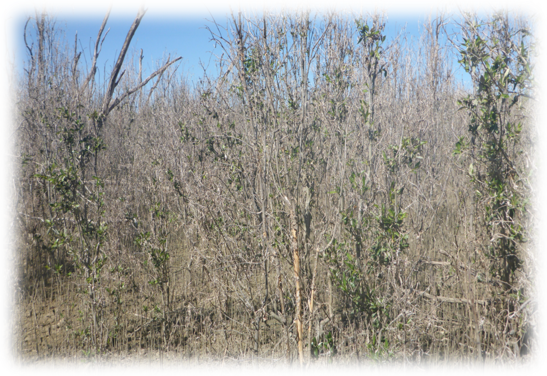
Mangrove dieback and the trajectory to recovery in the Gulf of CarpentariaMangrove dieback in the Gulf of Carpentaria was first detected in late 2015 to early 2016 and was reported to impact areas around the Gulf of Carpentaria from the tip of Cape York Peninsula Queensland to Groote Eylandt, Northern Territory[1][3]. The information provided below and in the Mangrove dieback and recovery in the Gulf of Carpentaria Map Story is based on the updated Mangrove trajectory to recovery post dieback in the Gulf of Carpentaria, Queensland report (released 2025) and provides updated (from a 2019 report) statistical information on mangrove dieback by catchment across the Queensland portion of the Gulf of Carpentaria and establishes a baseline to monitor the trajectory of recovery or decline of the mangrove and associated communities within this area.[2] This report also provides mangrove recovery assessment over the last seven years since recorded dieback occurred. The updated Mangrove trajectory to recovery post dieback in the Gulf of Carpentaria, Queensland (2025) report provides refined and updated mangrove dieback information and mangrove recovery assessment since the dieback. See also:
Quick facts
Project background and methodologyA program to monitor the future trajectory of the recovery of mangroves and associated communities within the Queensland portion of the Gulf of Carpentaria (from the western tip of the Cape York Peninsula to the Northern Territory border) was established in 2016. This program includes three phases:
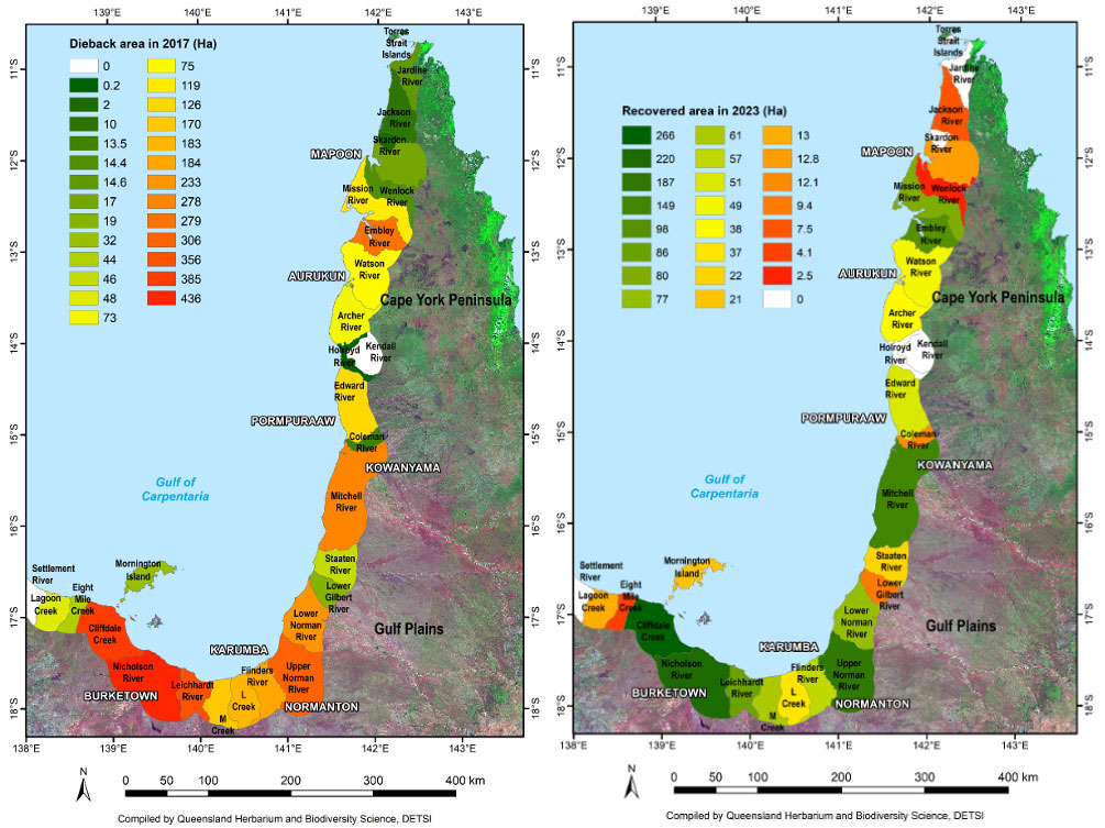
For phase one, three monitoring transects were established in the Karumba area in 2017 and five south of the Chapman River, Pormpuraaw in 2018. The information gathered in each transect includes full floristic and structural information following the vegetation mapping methodology using CORVEG sites[4]. Additional structural measurements of tree heights and diameter at breast height (dbh) as well as relative ground surface elevations were also captured. The second phase of the program was the mapping and change detection of mangrove dieback using large scale imagery (20 cm) and Lidar captured in August 2017 by Air Research Australia (ARA), and Earth–I 2017 satellite imagery (80 cm) in areas where the higher resolution imagery was not available. Since then, the mapping has been refined and a recovery assessment conducted across each of the catchment study areas. To assess the recovery, 2018 Earth_I and Sentinel 10m time series 2019 – 2023 imagery was used. Further assessments were conducted using google-earth recent Airbus imagery across the Gulf, and high-resolution (10cm) State Government imagery, for areas around Karumba and Pormpuraaw. ResultsThe 29 catchments in the study area were analysed for dieback, with 12 catchments each recording over 100 hectares of dieback with the highest occurring in the Nicholson River Catchment (436 ha). An additional 13 catchments had mangrove dieback extent from 0.2 hectares to 75 hectares. In two of the catchments assessed there was no dieback of mangrove recorded. Each catchment was mapped and was assessed for a number of patch analysis parameters to illustrate the extent and severity of the dieback in each catchment. The 29 catchments in the study area were analysed for recovery, with three catchments recovery over 10% of the dieback with the highest occurring in the Cliffdale Creek Catchment (17%, 266 ha). An additional 21 catchments had recorded recovery extents from 0.2% (3 ha) to 9.5% (149 ha). In five of the catchments assessed there was no recovery of mangroves recorded. The extent of mangrove within the Queensland portion of the Gulf of Carpentaria in 2015 was 149,797 ha, with 74,818 ha in the Gulf Plains Bioregion and 74,979 ha in the Cape York Peninsula Bioregion. The mapping of mangrove dieback in the study area identified 3,491 ha (2.3%) of mangrove dieback, with 2,787 ha (3.7%) in the Gulf Plains Bioregion and 704 ha (0.9%) in the Cape York Peninsula Bioregion. The primary mangrove species impacted by the mangrove dieback in the Gulf of Carpentaria dieback was Avicennia marina subsp. eucalyptifolia (northern grey mangrove). In total, 45% (1,569 ha) of area has recovered or is on the trajectory to recovery. The extent of recovery was 44% (1,239 ha) of the Gulf Plains Bioregion and 47% (330 ha) of the Cape York Peninsula Bioregion. Historical assessment, both in the Karumba and Pormpuraaw areas, illustrates that the mangrove dieback has not discriminated on tree age with deaths occurring in trees as young as six-years old, to trees which were at least 47-years old. The majority of the mangrove dieback area south of Pormpuraaw was open ocean in 1969 with large areas not being colonised by mangroves until after 1998. This reflects the rapid dynamics of mangrove communities and their associated sediments in the Gulf of Carpentaria. See further information about the dieback event, methodology and more by exploring the publication links at the top of the page. Earlier reports:
Additional informationReferences
Last updated: 27 April 2026 This page should be cited as: Department of the Environment, Tourism, Science and Innovation, Queensland (2026) Mangrove dieback and the trajectory to recovery in the Gulf of Carpentaria, WetlandInfo website, accessed 17 September 2026. https://wetlandinfo.detsi.qld.gov.au/wetlands/ecology/components/biota/flora/flora-structural/mangroves/mangrove-gulf.html |


Site footer


 — Department of the Environment, Tourism, Science and Innovation